|
General
Specification
|
|
Model#
EGM-001 (Ver. 4.5) - Global Navigator
|
|
New
Features:
|

|
- View
Garmin Topographic Maps Garmin
IMG format topo maps are now supported (not Bluecharts). A wide variety
of freely available third party topo maps can be downloaded from here.
Overlay Garmin IMG maps on any other Fugawi
supported raster or vector map such as a BSB chart, satellite image or
air photo.
- Upload
Garmin Maps
Unlocked Garmin IMG maps may be uploaded to a Garmin mapping GPS
receiver.
- GPS
Auto Detection
Fugawi will now auto detect a wide variety of GPS models when
connected to the Serial or USB port.
- Locked
FX4 Maps
Support added for raster FX4 maps locked with FX4
Locker.
- Optional
PathAway
Support for optional PathAway GPS
Software for Windows Mobile PDAs and Smartphones.
-
Vista
Support for Microsoft® Vista® operating system
|
|
The
USA Bonus Data Pack includes:
|

|
- Elevation
data of the
USA
(to display 3D land maps)
- Street
Overlay of the
USA
- Place
Names of the
USA
- MPC
Boaters Directory of the
USA
- NOAA
RNC® charts of all US Coastal Waters
- World
Background Map (1:1,000,000 scale)
|
|
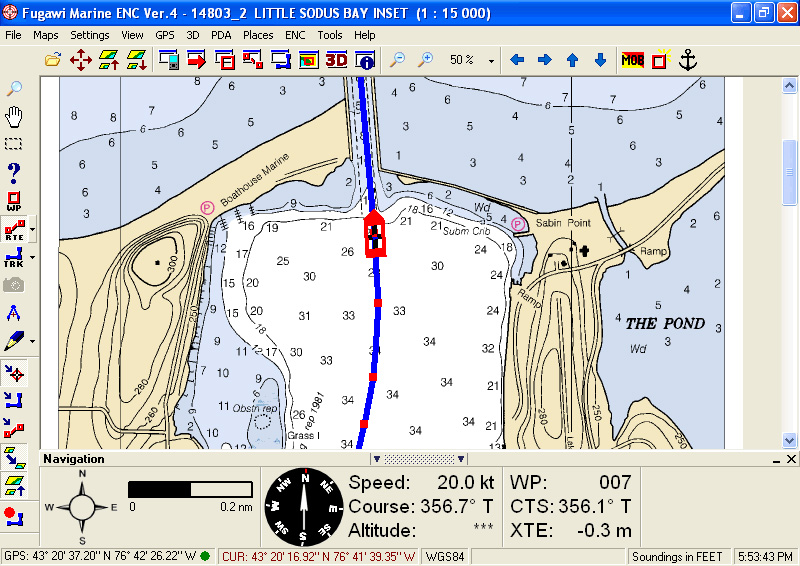
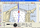
Real-time
Navigation
w/ Your Laptop or Desktop PC:
|
|
- Connect
your PC or laptop to GPS
receiver to view your position on a detailed chart, map, or
air photo. See speed, position, direction, ETA, and more.
|
|
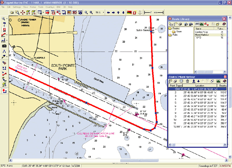
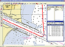
Plan
and Transfer Routes:
|
|
- Create
routes directly on a nautical chart, street map or topographic map and
transfer named waypoints, routes, and tracks between your PC and your
handheld GPS.
Transfer routes tracks and waypoints directly to Google
Earth, a GPX file.
|
|
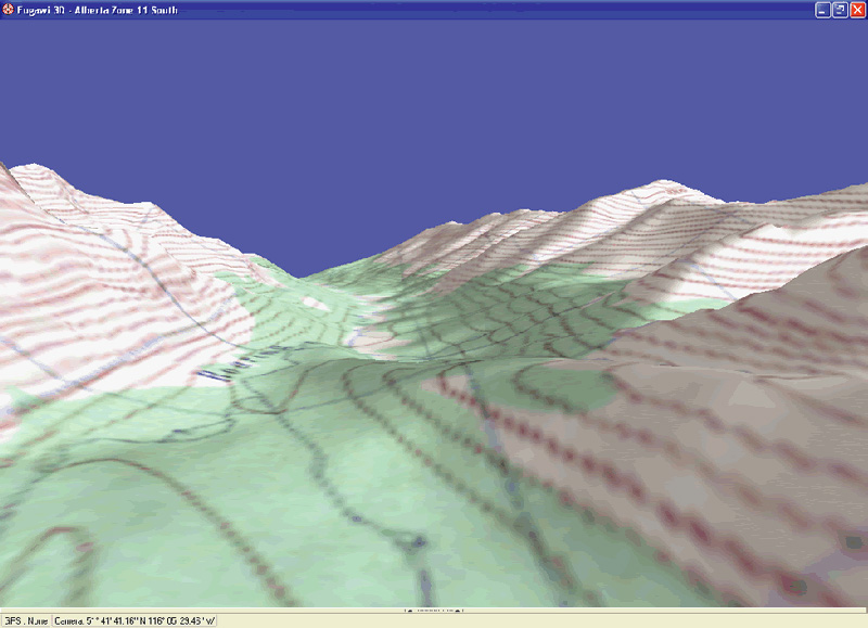
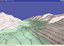
View
Maps in 3D:
|
|
- View your
favorite chart or map in stunning 3D*.
‘Fly’ across the 3D landscape using your mouse, keyboard, or
joystick, or view your GPS position in real-time on the 3D chart. A
great tool for finding the perfect hiking route.
|
|

|
|
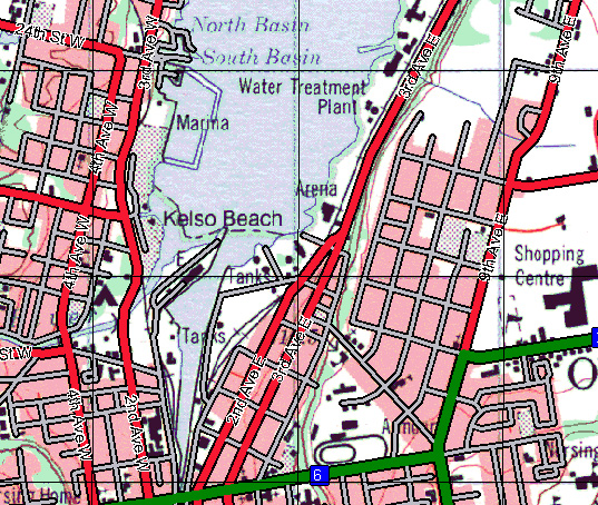
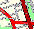
Overlay
Streets and Place Names:
|
|
- Street
Overlay™ enhances your marine chart or land map by drawing named
streets** directly on top. Millions
of included place names can also be added to the map.
|
|
Supported
Map Formats
|
- BSB Version 1
through 5 raster nautical charts (NOAA
RNC™, MAPTECH™, NDI DigitalOcean™, Fugawi, GPS GmbH)
- Garmin IMG format
maps (not Bluechart)
- Softchart charts
(NOS/GEO)
- World maps and
charts from the Fugawi collection (Fugawi Map of America, Fugawi Canada
Maps, Fugawi World Maps) in FX3 or FX4 format
- Locked FX4 Maps
(raster FX4 maps locked with FX4 Locker)
- Fugawi Street
Overlay™ and other Fugawi vector maps
- USGS DRG
Topographic Maps and aerial photos
- ECW (including
official Australian topo maps)
- SoftMap topo maps
Ver. 1-4 (No support for SoftMap Ver. 5, SoftMap not supported in
Microsoft Vista)
- eTopo
- TRAK Maps
- GeoGrid®
- Geotiff
- Chart Tiff maps and
charts
- TIFF+TFW
- ADRG (Military
version only)
- CADRG (Military
version only)
- CIB (Military
version only)
- Swedish Government
digital maps (optional extra upgrade)
- Swiss Map 50 and
Swiss Map 25 (Version 3)
- Calibrate any
scanned map or raster map file in bmp, gif, jpg, png, pcx, or tif format
(must know the map datum and coordinates for three points on the map or
have a prepared JPR file)
|
|
Supported
Elevation Data
|
- Fugawi Elevation
Files (FEL)
- Shuttle Radar
Topography (SRTM)
- BIL
- DTED
- SDTS
- Australian GRD 9
Second
|
|
System
Requirements
|
- Microsoft® Windows®
Vista or XP
- 500 MHz processor
or better
- 256 MB RAM
- 250 MB free on HD
- CD Drive
- DVD drive for Bonus
Data Pack
- 256 color display
or better (graphics accelerator recommended for 3D viewing)
- Mouse or other
pointing device
- Serial port for GPS
receiver (will also work with PCMCIA serial port emulation or USB with
serial adapter).
- Software package
does not contain GPS, cable, or handheld computer
|
|
GPS
Receiver
Requirements
|
- GPS receiver with
NMEA 0183 output
- Serial port or
PCMCIA emulation for GPS input or serial to USB adapter
- Supports waypoint,
route, and track transfer with most Garmin®, Magellan®, Lowrance®,
Silva/Brunton, Furuno, Raymarine, and other models. (Refer to the GPS
Compatibility table)
- Supports route
transfer with the Suunto X9 and X9i GPS wristwatches.
- Supports real-time
navigation with above models plus any GPS with NMEA V2.1 or greater
output (requires suitable serial or USB cable).
- Note: Fugawi Global
Navigator can be used without GPS to plot and export positions to a text
file, view maps and charts, and much more.
|
|